Last fall I provided a series of informal reviews on navigation apps that could be used with a GPS equipped Apple iPad. That would be the Wi-Fi/Cellular version, which is priced at a $130 premium to the WiFi only model in Canada. In theory these apps should also work with the the WiFi/Cellular version of the iPad Mini and the iPhone. After using these apps last summer I suspect the screen size of the iPhone and possibly the Mini is a little too small to be practical if you are traveling more than 20 kph, at least in our waters where there seems to be a rock every few hundred meters. In theory, if not in practice, these apps are also available for Android tablets and phones. The basic Nexus 7″ tablet, available for about $250, has the advantage that it has GPS built-in, and represents a significant savings over an iPad with GPS functionality. The “in practice” comment earlier relates to the fact that not all of these apps are yet available in an Android version.
All of the apps reviewed last fall have received updates over the winter. This review covers the changes in a general sense and updates my opinion of their value for my uses. A reminder, I operate a 21-foot Scout Dorado with a 150 hp Yamaha in and around Georgian Bay. There are a claimed 30,000 islands, and an estimated 100,000 shoals. We typically motor at about 40 kph to optimize travel time and fuel economy. Even at 40 kph things move by pretty quickly.
Becuase we still have ice on the Big Sound I have only been able to ‘desk test’ the upgrades. Desk use of the apps is really quite important. I spend hours looking over the charts and planning new routes and destinations. Google, Apple and Bing maps are well short of adequate when looking beyond where roads run, and available nautical charts are generally not detailed enough once you go off the charted courses. Paper charts also don’t zoom or scroll very well, although they do rotate very nicely.
The bottom line in my opinion (details follow).
#1 – Navionics for iPad (~$55.00, US & Canada)
#2 – iSailor for iPad (~$15.00, Lakes Superior, Huron Ontario, ..)
#3 – iNavX for iPad (~$120, app plus Georgian Bay only
#1 – Navionics
This app has made some changes in their app, but nothing that really makes a difference in my life. Although it’s not the cheapest it represents the best value in my opinion with vector graphic mapping and very good accuracy in terms of markers. I was also encouraged speaking to an individual at the Toronto Boat Show in January who said Navionics is actively doing depth measurements in Georgian Bay to fill in areas with limited existing information. Those are exactly the areas that I spend my time, off the beaten track. This is a good application that is easy to use on the boat and when sitting at the desk. The standard chart package covers all of the USA and Canada, much more than I need, but I’ve actually had fun using it while on a 3-hour dinner cruise out of Philadelphia on the Delaware River.
#2 – iSailor
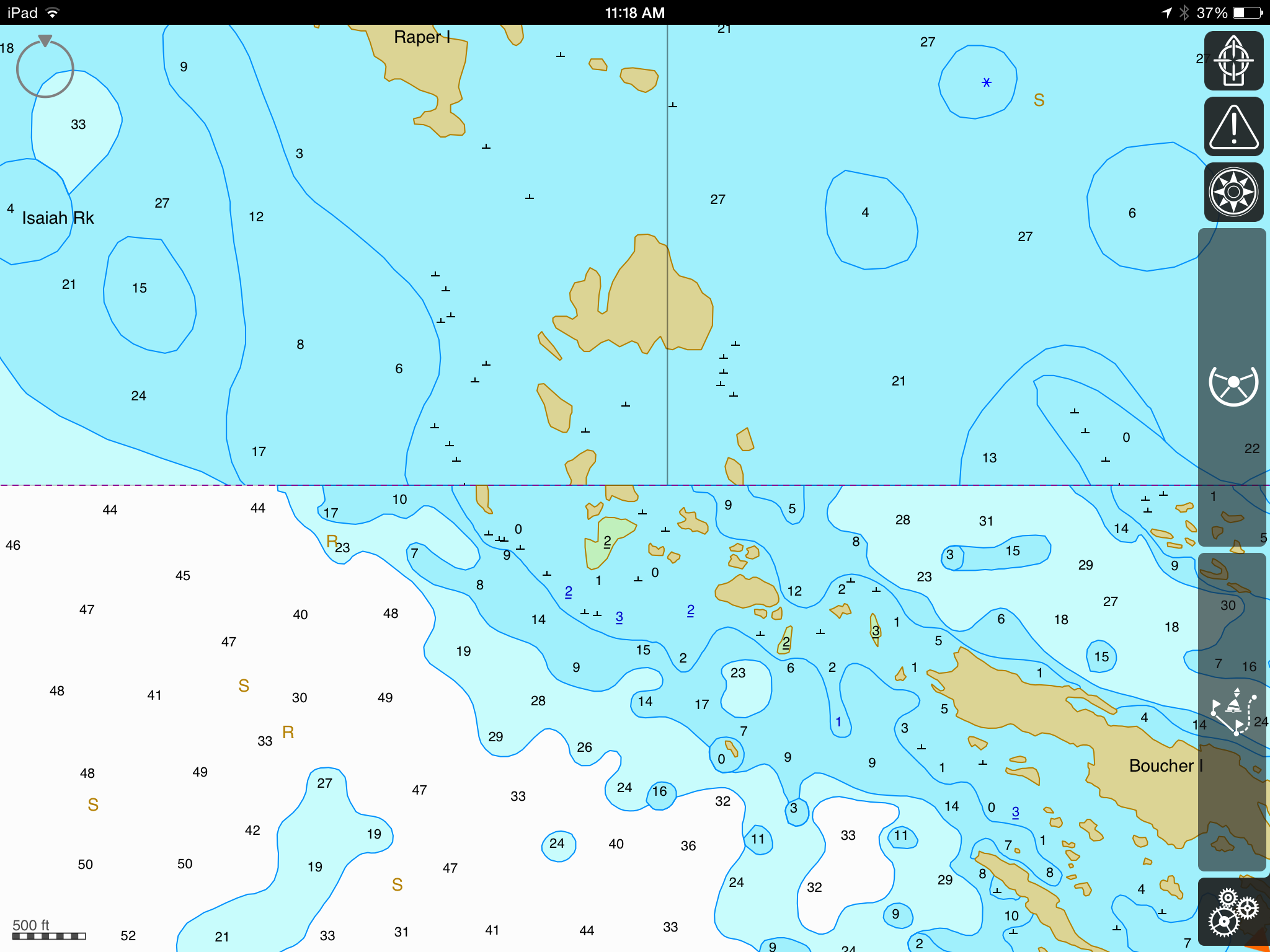
They recently announced a major overhaul of their interface. I guess it’s actually different, and presumably improved, but it really hasn’t registered with me. I have a couple of beefs with this app. The first is that it is missing markers in an area I regularly boat, the area outside of Regatta Bay in particular. I’ve spoken with them in the past and they added in the markers outside of Snug Harbour but are still missing Regatta Bay. If these markers are missing what else do I need to be worried about? The second issue concerns the mapping when I’m sitting at my desk and ‘snooping’ around for new destinations and routes. It seems the variously scaled charts maps don’t overlap properly and it just looks strange. This gets to be a real problem with the Mink Islands where actual islands are missing if you have the view at the wrong scale. It’s not an issue of the scale being too wide, it’s just a glitch in the system. But this app is the least expensive and if the markers are correct in your part of the world it represents a bargain.
Looking at the app again as I sit here writing this post I’m finding the app to be quite buggy, not only is there a misalignment of the charts, the markers come and go as I pinch to zoom in the various areas. The markers are visible when zoomed out but not zoomed in. I see that the markers for Regatta Bay are now shown, but only if you are zoomed out sufficiently. Zoom in and they are gone. Regarding the chart misalignment, here a screenshot showing the problem (click on the image to see a larger version).
#3 – iNavX
This was my first app for the iPad. It matched up with the strip charts. That’s a virtue and a real liability. The benefit is familiarity but your are limited to the strip charts. If you want to head a couple of kilometers off the charted routes you are on your own. The charts are not vector based, so there is a real limitation on zooming in on the details that don’t exist with the other two apps. Price is also an issue, for two reasons. The first is the $120 ‘start up’ cost to get just the Georgian Bay charts. It’s probably cheaper than the paper charts, but I still need to carry the paper charts if I’m boating commerically. And then there was the mid-winter upgrade. You know how it works, you get a message that an app has been updated, click here to update. Well I did just that with the iNavX app, which uses the Fugawi X-Traverse charts. When I then opened up the app all of my charts were gone. Gone! Not only was the app updated but my original charts were removed. I realize that I am not eligible for updated charts (things don’t change much in these parts), but delete the charts that cost me $60? My paper charts don’t disappear when there are updates. I contacted the company and was told I could get the updated charts for $10. Well that’s not too bad, but I still haven’t done it yet. I probably will pay the $10 to have them and salvage something from my original $120 purchase, but I’m still ticked off. Please, let me know that I’ll lose all of my charts if I choose a ‘free’ update. I was perfectly happy with the previous version of the app.
So there you have it, a users opinion of three navigation apps for the GPS equipped iPad. I may decide to try the Navionics app on my Google 7″ Nexus tablet (2013 version) but that promises to set me back $55 plus tax. It’s hard to rationalize when I have a paid-for 3rd Generation GPS equipped iPad sitting in an Otter Box. The Nexus is very useful when traveling in the car and you use it to complement a Garmin GPS system. That involves about a $2 investment in downloading road maps to the Nexus that can be used offline.