Parry Sound Area

Parry Sound Boat Launches – Champaigne Street

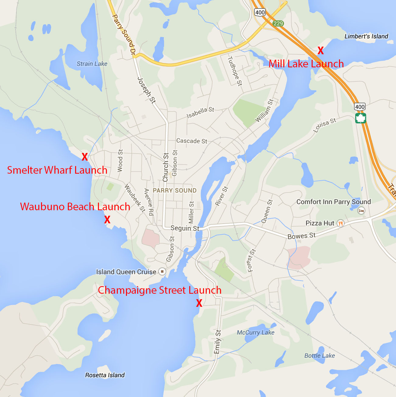
In the last post we presented a map identifying the free boat launches in Parry Sound. These launches will be familiar to those who have been coming to Parry Sound for  years. For those of you new to the area and wanting to get onto the Big Water, this information may be helpful. In this post we are looking at the Champaigne Street boat launch area. (Yes that’s the correct spelling, Champaigne, I went back to a 19th Century map to confirm the spelling. It could have been error at that time but it has stuck.)

The Champaigne Street launch is probably the most practical and useful for those who wish to come up to Parry Sound, launch their boat, and head out for a few days. It offers a reasonably good boat launch for anything up to 30-feet, perhaps more. There is also a barge ramp beside the launch for those with specialized needs. There are a total of three docks, about 40-feet long. Two are accessible from the shore, the third is a bit under water as it touches the shore. (Early 2013 image when the water was quite low, it’s closer to average at this point, 2014/05.)

WPSGN_Champaigne_Dock_2013

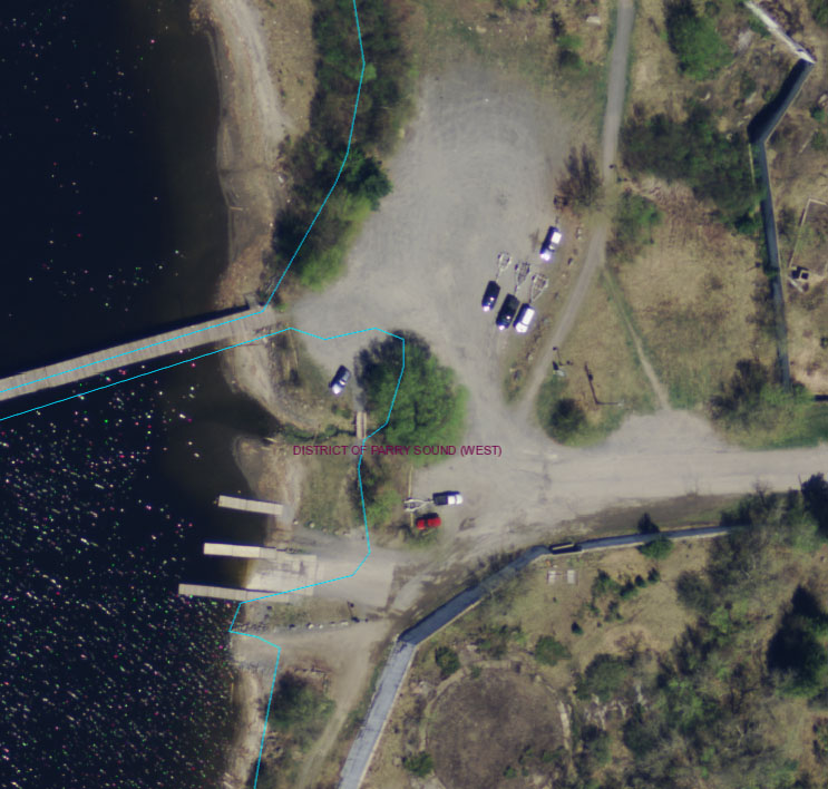
The docks are intended to be used for the loading and launching of boats rather than dockage. This boat launch can get busy and there is no room for boats to be tied up. Free dockage for a couple of hours has historically been available at Big Sound Marina, with charges for overnight dockage. Big Sound Marina has recently been put under new management and it’s possible that they might not extend courtesy dockage for people who want to get out and explore the Town, have a meal or resupply. Give them a call if you have any questions, here’s a link to their website..

The real appeal of the Champaigne Street boat launch is the availability of free parking for vehicle and trailer. The Town is relaxed with regard to parking at this site. I have had informal discussions with Town Staff and they indicated that there is no issue with parking there for a few days, let’s say four or less. Beyond that it is advisable to contact the Town to discuss a longer stay. They probably want to be sure that there is ‘fair’ use of the facility and people aren’t using the area as a ‘storage’ location.

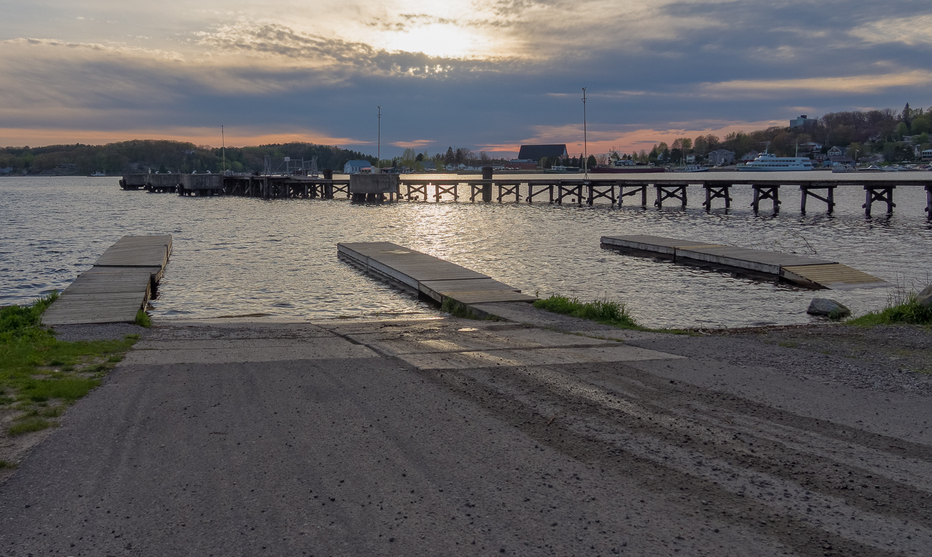
Here’s a photo of the boat launch taken later in the day. The larger dock you see a little further away is the former Imperial Oil dock that is now sitting unused. It cannot be accessed from the shore. The barge ramp is to the left and not shown.

OLYMPUS DIGITAL CAMERAFor those of you with more specialized needs Sound Boat Works offers a hydraulic trailer and crane with the ability to launch and haul power and sail boats up to about 55-feet (possibly even larger).


Parry Sound Boat Launches – Introduction

With Spring actually here, boats being launched, and the prospect of Summer, it’s perhaps worth providing an overview of the boat launches available in Parry Sound. Over the next couple of weeks there will be a series of posts providing information about the launches. This post provides a general overview of the launches.

The Town of Parry Sound provices the public with four no-fee boat launches. Not only can the boat launches be use at no cost, there is no charge to park vehicles and trailers for a reasonable length of time. Three of these boat launches provide access to Georgian Bay, via Parry Sound Harbour or the Big Sound, the fourth provides access to Mill Lake.

Here is a map of the area with the four boat launches marked in red. The roads on the map are a little misleading. All of the boat launches are easily accessed by all but the largest of commercial vehicles. In the next few posts we’ll take a look at each of the boat launches individually with attention to details that some may find important.

Parry Sound_Map_Labeled_2014-05-21

Click on the map for a larger version.

JB – Communications Officer


Training / Executive Officer’s April Update

On April 22, 12 boaters graduated from the Maritime Radio Course held at Lakeland. This is important for boaters since a certificate is needed when operating a VHF radio.

This is the time of year when boaters harass marina operators to get their boats into the water. Four or five calls per person is common. The local saying here is that the Sound is clear of ice within a week of April 21st. 2012 broke the belief with an early break up. Some boats were in the water on the first day of Spring. It looks as though 2014 will break it the other way.

So: Before planning on early season boating remember: The early bird gets the worm. The second mouse gets the cheese.

The early boater gets to boat alone. Silence and still water can be delightful but first boaters can be subject to the floating debris left after the ice is gone. This can range from planks and trees limbs to docks that have broken free.

The first mouse, the one who gets onto the bay before a strong wind has blown it clear of this debris, can have some dangerous experiences. Planks torn from docks, their four inch nails sticking up, can damage the smooth underwater hull of a boat. There is nothing like skimming along through an early Spring fog and having a tree, branches and all, loom out of the mist in front of you.

Then there is the ice. It doesn’t all melt overnight. An invisible skim of ice can do quite a number on a boat too. And if it does and your boat is sinking, who are you going to call who can possibly get to you any time soon? I do boat in the early season. My rules are simple. Carry the seven or eight items you must as demanded by law. Boat like you will never need to use them. Boat carefully, one hand for the boat – one for yourself, and make no mistakes. Or wait ’til things warm up some.

 Early Season ‘Boaters’ on the Big Sound – No WorriesParrySights-6905-2


State of the Sound Report – 2014-04-24

Not to be confused with the State of the Bay report (recommended reading) from the Georgian Bay Biosphere Reserve. As of yesterday evening, the Big Sound was icy white and thinning (much like my hair). The water is open from Parry Sound harbour to Three Mile Point in spots, but that’s about it. The photo below was taken yesterday evening from Monument Point on the North Shore Rugged Trail just north of Parry Sound looking west.

ParrySights-6842

December on the Big Sound

ParrySights-3374Looking out from the Smelter Wharf you can see Parry Island and Three Mile Point in the distance. taken December 23rd, the Big Sound is still wide open, while the Parry Sound inner harbour is iced over. I don’t expect that this will last for long. The nights have been clear and cold, and the Sound is rapidly losing its heat.

If you look closely you can see a sun dog a little left of centre.

Click on the photo for a larger image with more detail.

JB – Communications Officer

Delivering the Goods – Smelter Wharf

Following last week’s post I though it might be interesting to see a slightly more ‘romantic’ photo of a ‘saltie’ in the Parry sound Harbour. In this case it’s the Algorail delivering salt to the Smelter Wharf in the outer Parry Sound harbour.

ParrySights-


At this point she’s fully unloaded with the draft marks showing her sitting at about 12 feet. The draft marks go up to 30 feet.

There’s more water at the Smelter Wharf than in the inner harbour. Right beside the wharf the charts show a little more than 20 feet, but this quickly drops off to 45 feet and then 75 feet.  Not quite the same challenge as docking at the inner harbour of Parry Sound. I suspect that there might be a little bit of grinding when the ‘saltie’ first pulls into position at the dock given how close it is tied to the wharf, the 20 foot depth at that spot, and the somewhat lower water levels this time of year.

JB – Communications Officer

Delivering the Goods

Last week the Mississagi arrived in Parry Sound to deliver what I expect was the last salt delivery of the season. It was later than I remember but it seems the winds we experienced for most of November had kept the ‘salties’ from delivering salt to the docks in the Parry Sound harbour and the Smelter Wharf. I was told the waves were on the order of 12 feet for much of November in the harbour in Goderich they are loaded from.

While watching the Mississagi land and start to unload the I spoke with a local resident who has been watching the ‘salties’ arrive and unload for decades. She mentioned that the Mississagi was able to get into the inner harbour because of her relatively shallow draft. You can see that at the point this photo was taken she was taking on about 21 feet, well above (below?) what she is able to carry. At this point she had not yet started to unload. It was mentioned to me that the harbour is quite shallow and requires a remarkably shallow draft, from a laker standpoint, to enter the inner harbour. (Click on the image for a larger view that makes it easier to see the draft marks.)

ParrySights-0781

So I though t it might be interesting to take a look at the chart depths for a vessel as it enters the inner harbour passing through the gap between Salt Point and Bob’s Point. Pull out your charts and follow along.

It turns out that at one point the chart data shows a depth of a little more than 22 feet in the channel just before one reaches the red spar buoy (P42). And even as one emerges from the gap just past the breakwater for Big Sound Marina, the depth is still only 24 feet, with 21 feet marked a little to the west of a line defined by the ranges. The chart shows that the depth off of the dock where the Mississagi is shown tied up is 23 feet, and quickly drops to 14 feet as you approach the shore.

Given the relatively shallow depths involved and the proximity of Sound Boat works (seen in the background) I am impressed with how quickly the Mississsagi was able to enter the harbour, line itself up, and start unloading. It took less than 15 minutes to maneuver from a position perpendicular to the dock, to being tied up with the conveyer structure positioned over the dock. It was perfect day in terms of wind and waves, but impressive nonetheless.

Delivering the Goods

ParrySights-2669