Author: Jo Bossart/ParrySounds.com

Geocache Placed – Wreck Island

Parry Sound Power and Sail Squadron’s sixth GeoBayCache has been placed and confirmed on Wreck Island in the Massasauga Provincial Park. It’s officially Cache #2.

The cache coordinates are:
45.139549º
-080.107821º

This is the same as:
45º 08.373′
-080º 05.909′

Depending on whether you are using a Degrees or Degrees/Minutes format.

This is an easier cache to access from the government docks at Wreck Island. The cache itself is less than a hundred meters away from the picnic area. As you are well aware GPS coordinates are at best ‘close’, for a variety of reasons they may be +/- up to ten meters ‘off’. So be sure to look around for the cache in the general area of the coordinates. To make things a little easier a couple of photos are posted below that can help you locate the cache. Please post up a note on our Facebook page, or a comment on this site, when you locate one of the caches.

The Cache on Wreck Island

IMG_1240 IMG_1239

Water Levels – High, Low or Normal?

After last year’s remarkably low water levels in the Parry Sound region of Georgian Bay this year has seen a welcome rebound. The question now is whether the levels are still low, somewhat high, or perhaps ‘normal’. Well the levels certainly aren’t ‘normal’ in as much as there is seemingly no real normal with anything remotely impacted by weather and climate. What can be reasonably asked is whether water levels in this part of Georgian Bay are close to the historical averages and/or chart datum.

With respect to chart datum in June it seems we are about 0.6 meters above the mean average low water levels and 0.8 meters below the average high water levels. Comfortable average perhaps? Here’s a link to the most revcent Canadian Hydrographic Service data.

Here’s a simpler measure of water levels – a photograph of Zhiishib Rock in the Big Sound just outside Parry Sound harbour. Taken last week with calm conditions  it suggests we are probably close to average in terms of water level. There doesn’t seem to be a high water mark, the topmost dark line, much above the current level, perhaps 20 centimeters (8 inches) or so. This may well represent the mean high water mark for the last few  decades where there has been a fluctuation between alarming high and low water levels. (Click on the photo below for a larger version.)

OLYMPUS DIGITAL CAMERA

Regardless, the water levels make boating a bit more comfortable in the area. I was talking to one sailboater who said he was able to get into the government dock at The Pancakes for the first time in a decade.

Despite the high water levels it seems boating traffic is down in this part of Georgian Bay. It might be the higher price of fuel, but it’s probably the cooler and less predictable weather. Temperatures certainly seem to be ‘comfortably cool’ for this time of year with a bit more rain than might be expected. That’s based on my realization that the lawn and garden haven’t yet required watering, and there hasn’t been a need for fans in the windows.

Boating this year is wonderful – lots of water and not too hot. Come on up and enjoy it while summer is still around to welcome you.

JB – Communications Officer

Geocache Placed – Windsor Island

Parry Sound Power and Sail Squadron’s fifth GeoBayCache has been placed and confirmed on Windsor Island, on the southwest of Franklin Island. It’s officially Cache #6.

The cache coordinates are:
45.38033º
-080.34578º

This is the same as:
45º 22.820′
-080º 20.747′

Depending on whether you are using a Degrees or Degrees/Minutes format.

This is a trickier cache to access as there is no government dock. It will mean pulling up to the shore or anchoring out and using a dinghy to get to shore. It has been suggested that the best approach is from the east in an area that is referred to as Windsor Island Harbour. On some charts an anchorage is shown that is close to where the cache can be found.

Geocache Placed – The Pancakes

Parry Sound Power and Sail Squadron’s fourth GeoBayCache has been placed and confirmed on The Pancakes, an island a couple of kilometres south of Snug Harbour. (Our Commander managed to place this one and a couple others last weekend and I’m just getting around to posting them up.) It’s officially Cache #9.

The cache coordinates are:
45.34040º
-080.29472º

This is the same as:
45º 20.424′
-080º 17.683′

Depending on whether you are using a Degrees or Degrees/Minutes format.

There is a government dock on The Pancakes, but it can fill up so be prepared to circle back in an hour if you don’t want to anchor and ‘dinghy’ in to shore. The water is high enough that access to the dock is much easier than in previous years. The island itself is quite flat, ergo the name, and quite easy to get around and explore. It also offers some crude but quite usable bathroom facilities.

As always (You are a Power Squadron graduate aren’t you?) be careful on the water and on the islands. You may come across poison ivy and the protected Eastern Massasauga Rattlesnake. Neither should be a concern if you keep your eyes and ears open and your hands to yourself.

Check out information at the Parry Sound Power and Sail Squadron GeoBayCaching page for information on the Squadron’s geocaching program.

Geocache Placed – Regatta Bay (Franklin Island)

Parry Sound Power and Sail Squadron’s third GeoBayCache has been placed and confirmed in the Regatta Bay area on Franklin Island. It’s officially Cache #3.

The cache coordinates are:
45.38583º
-080.33467º

This is the same as:
45º 23.150′
-080º 20.080′

Depending on whether you are using a Degrees or Degrees/Minutes format.

There is no government dock in Regatta Bay so you will need to anchor or pull up on shore to find the cache. Wet feet are a possibility. Come August you should find Cardinal flowers marking the general area. The cache itself is not really hidden. The idea of the program is to provide boaters with an opportunity to explore new spots in the Georgian Bay Biosphere.

There seems to be lots of water this year, so there shouldn’t be too many surprises if you follow the charted routes. But be careful on the water and on the islands, you are likely to come across poison ivy and the protected Eastern Massasauga Rattlesnake. Neither should be a concern if you keep your eyes and ears open and your hands to yourself.

Check out information at the Parry Sound Power and Sail Squadron GeoBayCaching page for information on the Squadron’s geocaching program.

Geocache Placed – Copegog Island

Parry Sound Power and Sail Squadron’s second GeoBayCache has been placed and confirmed on Copegog Island. It’s officially Cache #8.

The cache coordinates are:
45.25237º
-080.20081º

This is the same as:
45º 15.14220′
-080º 12.04860′

Depending on whether you are using a Degrees/Minutes or Degrees format.

As with the Huckleberry Island Cache there is a government dock, in this case co-sponsored with the Wasauksing Band, so there won’t be wet feet. The cache itself is on the other side of the island from the dock, less than a 100 meters away, and not really hidden. The idea of the program is to provide boaters with an opportunity to explore new spots in the Georgian Bay Biosphere.

There seems to be lots of water this year, so there shouldn’t be too many surprises if you follow the charted routes. But be careful on the water and on the islands, you are likely to come across poison ivy and the protected Eastern Massasauga Rattlesnake. Neither should be a concern if you keep your eyes and ears open and your hands to yourself.

Check out information at the Parry Sound Power and Sail Squadron GeoBayCaching page for information on the Squadron’s geocaching program.

The Dockage at Copegog Island (July 2014)

OLYMPUS DIGITAL CAMERA

Blessing of the Fleet

Adapting a maritime tradition to our local waters the Parry Sound Power and Sail Squadron Executive Officer, and Past Commander, the Reverend Doctor David Hardie will be offering a ‘blessing of the fleet’ on July 1st as part of the Squadron’s Christmas in July event.

Dr. Hardie will be offering the blessing for vessels attending the Christmas in July procession (all are invited to participate – please see an earlier post for information on when and where), at about 9:15 PM after boats have assembled behind Rosetta Island in the Parry Sound harbour.


First Geocache Placed – Huckleberry Island

Parry Sound Power and Sail Squadron’s first GeoBayCache has been placed and confirmed on Huckleberry Island. It’s officially Cache #5, but managed to get placed first.

The cache coordinates are:
45.40139º
-80.11776º

This is the same as:
45º 24.08340′
-080º 07.06560′

Depending on where you are using decimal degrees or degrees and minutes.

Good news – with a government dock so there won’t be wet feet. The cache itself is a bit tucked away from the elements, but not really hidden. The idea of the program is to provide boaters with an opportunity to explore new spots in the Georgian Bay Biosphere.

Check out information at the Parry Sound Power and Sail Squadron GeoBayCaching page for information on the Squadron’s geocaching program. Additional information about Cache #5 can be found at the page on the website.

ParrySights-1130

Christmas in July

Where? – Parry Sound Harbour
When? – July 1st, 9:15 PM

Every year the Parry Sound Power and Sail Squadron sponsors Christmas In July. You don’t have to be a member to express your holiday spirit. Just decorate your boat like a lighted Christmas tree or present and join us.

How? – Decorate your boat and join us behind Rosetta Island at 9:15 on July 1 – Canada Day. Or, if the day is Parry Sound perfect, anchor south of Rosetta (there is shallow water near Parry Island) – have a Bar-B-Q, swim, decorate your boat and join us south of Rosetta Island at 9:15

The parade of lights will leave at 9:40 led by the OPP boat or Cambrian. We travel in line toward Parry Sound Marine then loop to travel along the east side of the concrete wharf (many cheers and halloos, here.) We then try to head out past Bobs Point before the Island Queen returns from her evening cruise. We then tour toward the Old Town beach and Parry Sound Sailing School so the residents of Belvedere can see us. Hopefully we can get back and anchored for the fireworks.

Of course a skipper is responsible for his/her own boat. When and where you break off from the procession is up to you. One year in twenty, I remember a thunder storm that caused a change in plans. Grandchildren can insist that fireworks are more important than a long cruise. But I have never regretted being a part of this Canada Day celebration.

After the fireworks there tends to be total confusion in the harbor. I usually leave my boat anchored and fire up ALL my lights until things quiet down. On other nights I have followed boats out toward the Sound – boats with no lights, boats with their red and green lights backwards. I find it best to wait. On the other hand, even with the crowded harbor we have never had a collision.

Hope to see you at Rosetta this July 1. Contact me if you have questions: John Mason, commander@parrysoundsquadron.ca.

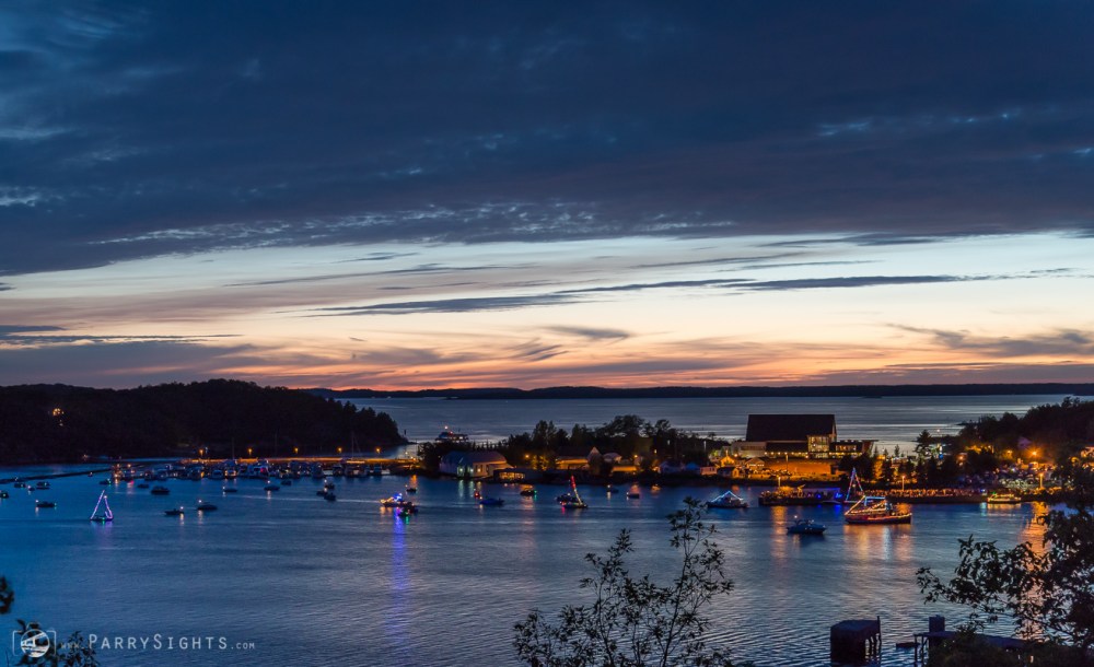
Last Year’s Christmas in July Procession

ParrySights-8635b


Parry Sound Boat Launches – Mill Lake

This is the final installment in the series on boat launches in Parry Sound. Previous posts provided an overview of all sites with individual posts on the Champaigne Street, Waubuno Beach and Smelter Wharf launches. While these launches all provide access to Georgian Bay the Mill Lake launch provides access to, surprise, Mill Lake.

This launch is in a corner of Parry Sound just on the north east side of the Highway 400 bridges that cross the Seguin River and many people assume is part of the neighbouring municipality of McDougall. Mill Lake itself is a smaller lake that does not provide access to either Georgian Bay or other lakes in the area. It is largely surrounded by cottages and homes. Here is an aerial look at the boat launch.

Mill-Lake_Launch_WPSGN

The launch itself is shallow with a gravel base, suitable for the boats that might be used on this smaller lake. Parking is available and once again I suggest people contact the Town of Parry Sound if they want to leave their vehicle and trailer there for any extended period of time.  Here’s a photo looking at the launch area. It’s a pretty relaxed facility with few users and lots of space.

OLYMPUS DIGITAL CAMERA

The dock is about 40-feet in length. A sign at the launch states that dockage is limited to four hours.

That’s it for the review of boat launches in Parry Sound. With a little bit of help we may be able to provide information on boat launches in the surrounding communities.

JB – Communications Officer