Parry Sound Area

One Hand for the Boat. One for Yourself.

One hand for the boat; one for yourself. It’s a mantra repeated over and over by experienced boaters. Don’t let go of the boat. How many times I pointed out to Nat that he was standing in the dinghy with nothing in his hands; that he walked the length of the boat with little care to hold on.

Anchored in Regatta Bay, I was working down below while Nat learned to row the inflatable. I heard him come to the side of the boat, slide the oars into the cockpit, then little sound for a while until SPLASH!

By the time got my head outside he was swimming toward the boat. PFD holding him well out of the water; dinghy painter in his teeth, he was dog paddling – you couldn’t call it swimming – toward the boat.

After putting the oars into our boat he had planned to tie the dinghy to the boat. But he had let go and the wind had another idea. Now he was getting back to the boat the best he could.

We had another talk. But I think this experience might stick better. We will see.

Nathaniel Tows the Dinghy Home

PSPS - Nathaniel

JM – Commander (iPad sketch using Art Set app)

Using Google Earth for Local Navigation

If you boat among the 30,000 Islands of Georgian Bay you are well aware of the many hidden rocks and shoals that seem to wait, daring you to come their way. A couple of days ago I saw a 40-foot power boat onshore with its bow ripped apart following an unadvised shortcut between channels. That’s life exploring the Georgian Bay Biosphere. Stay in the small craft route and you are guaranteed to have no surprises. Wander off the ‘beaten track’ into the more interesting areas and you take responsibility for what happens.

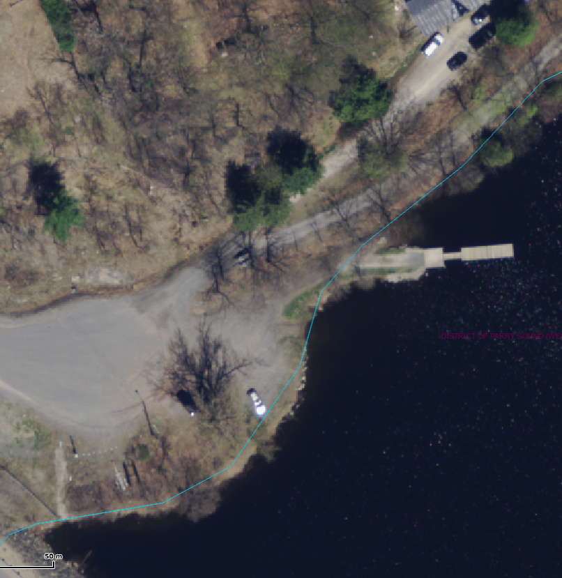
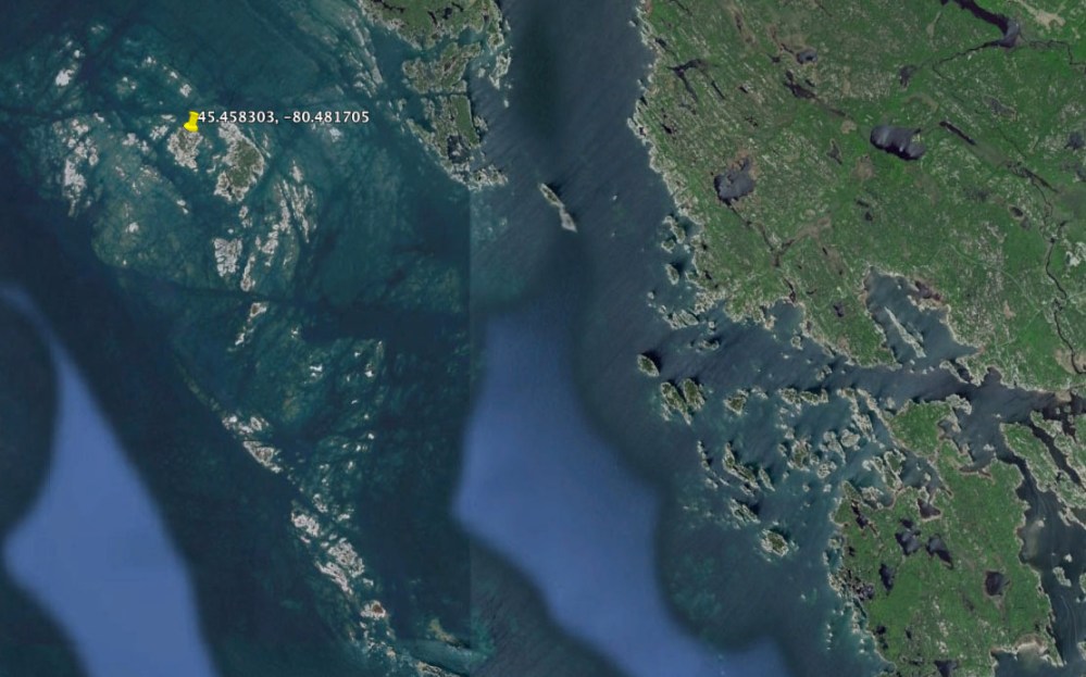
In a series of reviews last year I looked at how iPad apps from Navionics, iSailor and iNavX made it much easier to head off the small craft routes and explore some of the thirty thousand islands. Well these apps are great but they are not perfect as I found out last weekend on a trip from Parry Sound to Little McCoy Island (45.458303, -80.481705). This was a new destination for us and I spoke with couple of people about the best route to take as well as consulting with the Navionics and iSailor apps on my iPad. On route I was careful to ensure I stayed on my planned route using the Navionics app. Here’s a snapshot of the path once beyond the charted small craft route. The darker blue represents a depth of less than 6 feet while white represents depths of more than 6 feet. Boating with our 21-foot Scout and 150-hp Yamaha outboard I’m pretty comfortable with depths of 4-feet or more, and right now we are dealing with water levels at or slightly above chart datum.

LittleMcCoy_v1
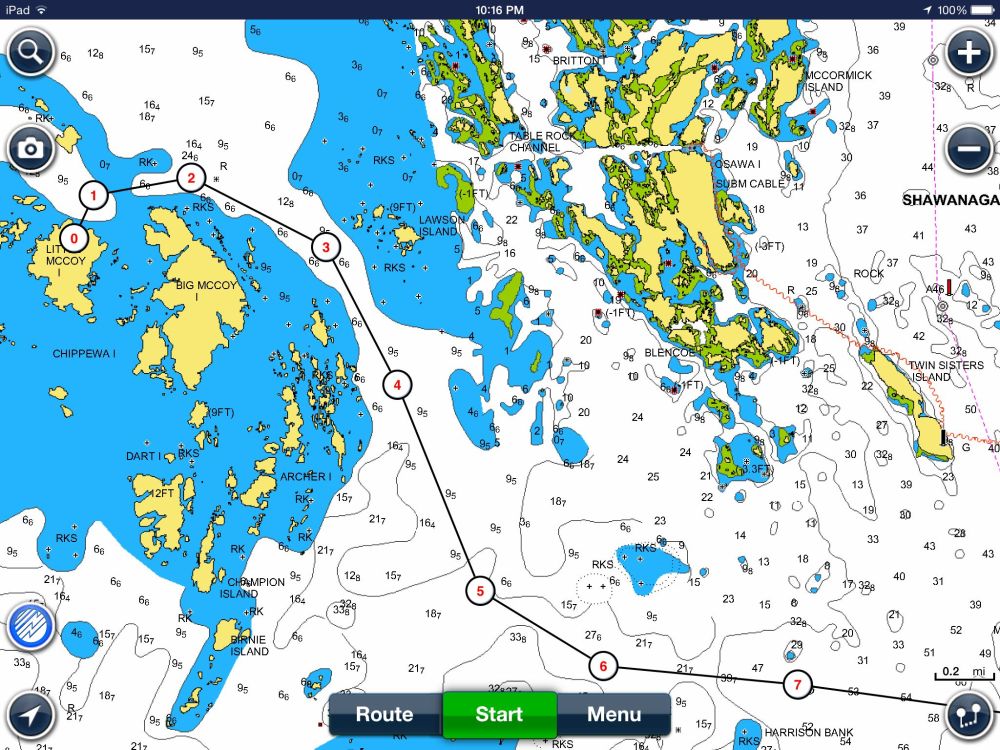
Heading west of Franklin Island towards Little McCoy.

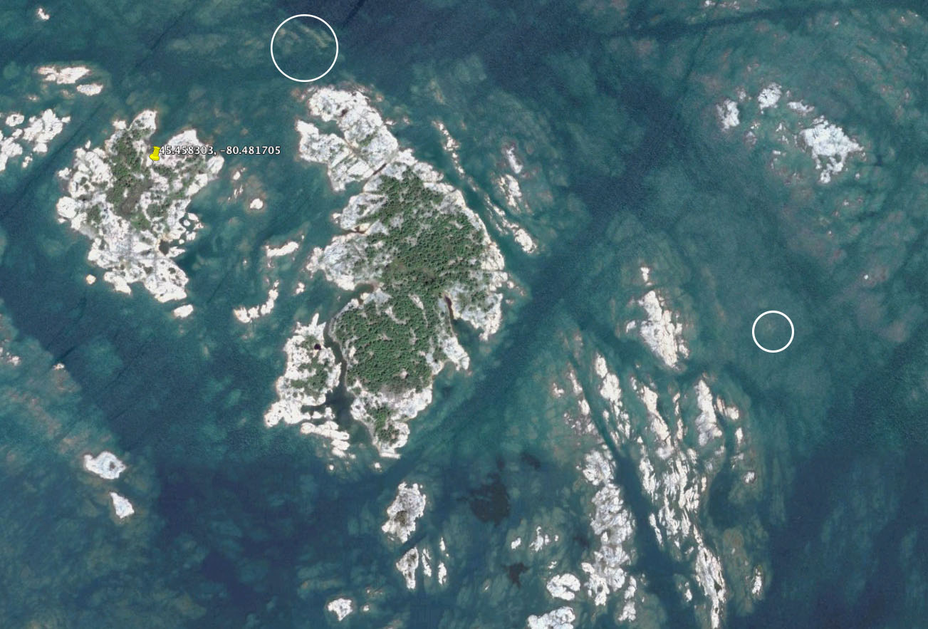
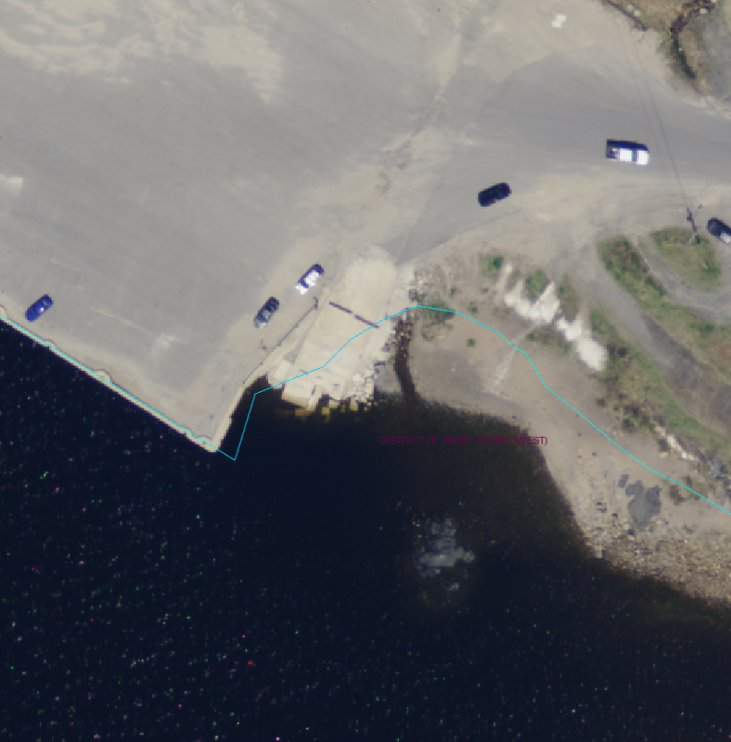
Here’s a closer look as you approach the McCoy’s. It’s pretty obvious that there is a safe seam running east of the McCoy Islands with issues just as you approach Little McCoy Island. Or so you would think.

LittleMcCoy_v2

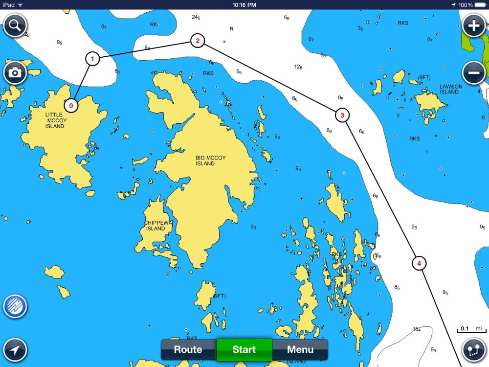
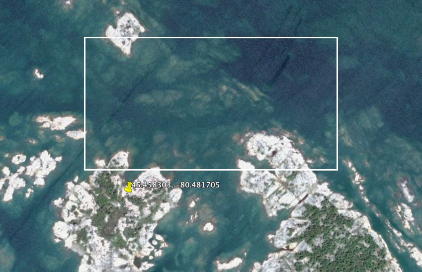
On the way in I managed to ding the prop, not too seriously, about where you see the Number 2 on the Navionics chart. (Click image for a larger view.) On the way back I suffered a separate ding, at higher speed, between points 3 and 4. According to the charts I was in an area that should have had more than 6-feet of water. In particular the ding beyond point 3 (heading south) was a surprise, as evidenced by the fact that I was confidently moving at about 40 kph (25 mph) – ouch, ouch, ouch. There had been no problem on the way in and I was pretty much on the same track. (That’s another nice feature of Navionics and iSailor, you are able to lay down a track that you can follow when returning.)

Now about Google Earth. In this part of the world Google Earth and Google maps have on and off coverage, here’s an example of the area around Franklin Island and the McCoys. In those areas where there is a stretch of open water they generally choose to blur out the area with a not very aqua blue. (Hey it’s just water what else is there to show?)

Google_Earth_Franklin-McCoys

Looking closer (below), Google Earth can explain what I ‘discovered’ on my way in and out of Little McCoy. It’s pretty obvious that there is a seam in the channel that is consistent with the Navionics charts. But they are not perfect seams as you can see looking a little closer. I’ve tried to approximate the ‘ding points’ on the Google Earth projection and you can see what I discovered with the bottom of my outboard. What Navionics didn’t catch were the several shallow points in the area identified as 6-feet or deeper. No criticism of the app, they can’t be expected to have information on every square foot of Georgian Bay.

Google_Earth_McCoys_Ding_Points

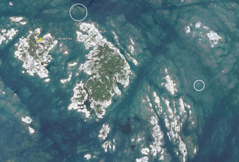
What is interesting is the area north of Big McCoy Island (below). Contrary to what is indicated by Navionics it seems the safer route is closer, not further away, from the island.

Google_Earth_McCoys_North

Lesson learned and a look at Google Earth will be part of my standard operating procedure when wandering too far off the well charted areas. Actually I will  pay better attention to the Google Earth information and plot some of the more challenging points on the Navionics charts. The irony is that I did look at the Google Earth maps before heading out but failed to look close enough and map it against the Navionics chart data.

Google Earth and Navionics seem to be a natural fit and worth exploring before heading out. Whatever type of ding the prop and skeg took it didn’t impact performance on the way back, but I haven’t yet had the courage to tilt the engine forward and take a look.

JB – Communications Officer


Geocache Placed – Winnett Island

Parry Sound Power and Sail Squadron’s seventh GeoBayCache has been placed and confirmed on Winnett Island. It’s officially Cache #5.

The cache coordinates are:
45.178171º
-80.098477º

This is the same as:

45°10.6903′
-080°05.9086′

Depending on whether you are using a Degrees or Degrees/Minutes format.

This is an easier cache to access from the government docks at Winnett Island, there seems to be lots of deep water. The cache itself is less than a couple hundred meters away from the dock area. As you are well aware GPS coordinates are at best ‘close’, for a variety of reasons they may be +/- up to ten meters ‘off’. So be sure to look around for the cache in the general area of the coordinates. To make things a little easier a couple of photos are posted below that can help you locate the cache. Please post up a note on our Facebook page, or a comment on this site, when you locate one of the caches. Let us know if the cache is missing (it shouldn’t be too hard to find), or it is damaged or missing any items (notepad, pencil/pen, cache cards).

Cache on Winnett Island

IMG_1243 IMG_1242

Geocache Placed – Wreck Island

Parry Sound Power and Sail Squadron’s sixth GeoBayCache has been placed and confirmed on Wreck Island in the Massasauga Provincial Park. It’s officially Cache #2.

The cache coordinates are:
45.139549º
-080.107821º

This is the same as:
45º 08.373′
-080º 05.909′

Depending on whether you are using a Degrees or Degrees/Minutes format.

This is an easier cache to access from the government docks at Wreck Island. The cache itself is less than a hundred meters away from the picnic area. As you are well aware GPS coordinates are at best ‘close’, for a variety of reasons they may be +/- up to ten meters ‘off’. So be sure to look around for the cache in the general area of the coordinates. To make things a little easier a couple of photos are posted below that can help you locate the cache. Please post up a note on our Facebook page, or a comment on this site, when you locate one of the caches.

The Cache on Wreck Island

IMG_1240 IMG_1239

Water Levels – High, Low or Normal?

After last year’s remarkably low water levels in the Parry Sound region of Georgian Bay this year has seen a welcome rebound. The question now is whether the levels are still low, somewhat high, or perhaps ‘normal’. Well the levels certainly aren’t ‘normal’ in as much as there is seemingly no real normal with anything remotely impacted by weather and climate. What can be reasonably asked is whether water levels in this part of Georgian Bay are close to the historical averages and/or chart datum.

With respect to chart datum in June it seems we are about 0.6 meters above the mean average low water levels and 0.8 meters below the average high water levels. Comfortable average perhaps? Here’s a link to the most revcent Canadian Hydrographic Service data.

Here’s a simpler measure of water levels – a photograph of Zhiishib Rock in the Big Sound just outside Parry Sound harbour. Taken last week with calm conditions  it suggests we are probably close to average in terms of water level. There doesn’t seem to be a high water mark, the topmost dark line, much above the current level, perhaps 20 centimeters (8 inches) or so. This may well represent the mean high water mark for the last few  decades where there has been a fluctuation between alarming high and low water levels. (Click on the photo below for a larger version.)

OLYMPUS DIGITAL CAMERA

Regardless, the water levels make boating a bit more comfortable in the area. I was talking to one sailboater who said he was able to get into the government dock at The Pancakes for the first time in a decade.

Despite the high water levels it seems boating traffic is down in this part of Georgian Bay. It might be the higher price of fuel, but it’s probably the cooler and less predictable weather. Temperatures certainly seem to be ‘comfortably cool’ for this time of year with a bit more rain than might be expected. That’s based on my realization that the lawn and garden haven’t yet required watering, and there hasn’t been a need for fans in the windows.

Boating this year is wonderful – lots of water and not too hot. Come on up and enjoy it while summer is still around to welcome you.

JB – Communications Officer

Blessing of the Fleet

Adapting a maritime tradition to our local waters the Parry Sound Power and Sail Squadron Executive Officer, and Past Commander, the Reverend Doctor David Hardie will be offering a ‘blessing of the fleet’ on July 1st as part of the Squadron’s Christmas in July event.

Dr. Hardie will be offering the blessing for vessels attending the Christmas in July procession (all are invited to participate – please see an earlier post for information on when and where), at about 9:15 PM after boats have assembled behind Rosetta Island in the Parry Sound harbour.


Christmas in July

Where? – Parry Sound Harbour
When? – July 1st, 9:15 PM

Every year the Parry Sound Power and Sail Squadron sponsors Christmas In July. You don’t have to be a member to express your holiday spirit. Just decorate your boat like a lighted Christmas tree or present and join us.

How? – Decorate your boat and join us behind Rosetta Island at 9:15 on July 1 – Canada Day. Or, if the day is Parry Sound perfect, anchor south of Rosetta (there is shallow water near Parry Island) – have a Bar-B-Q, swim, decorate your boat and join us south of Rosetta Island at 9:15

The parade of lights will leave at 9:40 led by the OPP boat or Cambrian. We travel in line toward Parry Sound Marine then loop to travel along the east side of the concrete wharf (many cheers and halloos, here.) We then try to head out past Bobs Point before the Island Queen returns from her evening cruise. We then tour toward the Old Town beach and Parry Sound Sailing School so the residents of Belvedere can see us. Hopefully we can get back and anchored for the fireworks.

Of course a skipper is responsible for his/her own boat. When and where you break off from the procession is up to you. One year in twenty, I remember a thunder storm that caused a change in plans. Grandchildren can insist that fireworks are more important than a long cruise. But I have never regretted being a part of this Canada Day celebration.

After the fireworks there tends to be total confusion in the harbor. I usually leave my boat anchored and fire up ALL my lights until things quiet down. On other nights I have followed boats out toward the Sound – boats with no lights, boats with their red and green lights backwards. I find it best to wait. On the other hand, even with the crowded harbor we have never had a collision.

Hope to see you at Rosetta this July 1. Contact me if you have questions: John Mason, commander@parrysoundsquadron.ca.

Last Year’s Christmas in July Procession

ParrySights-8635b


Parry Sound Boat Launches – Mill Lake

This is the final installment in the series on boat launches in Parry Sound. Previous posts provided an overview of all sites with individual posts on the Champaigne Street, Waubuno Beach and Smelter Wharf launches. While these launches all provide access to Georgian Bay the Mill Lake launch provides access to, surprise, Mill Lake.

This launch is in a corner of Parry Sound just on the north east side of the Highway 400 bridges that cross the Seguin River and many people assume is part of the neighbouring municipality of McDougall. Mill Lake itself is a smaller lake that does not provide access to either Georgian Bay or other lakes in the area. It is largely surrounded by cottages and homes. Here is an aerial look at the boat launch.

Mill-Lake_Launch_WPSGN

The launch itself is shallow with a gravel base, suitable for the boats that might be used on this smaller lake. Parking is available and once again I suggest people contact the Town of Parry Sound if they want to leave their vehicle and trailer there for any extended period of time.  Here’s a photo looking at the launch area. It’s a pretty relaxed facility with few users and lots of space.

OLYMPUS DIGITAL CAMERA

The dock is about 40-feet in length. A sign at the launch states that dockage is limited to four hours.

That’s it for the review of boat launches in Parry Sound. With a little bit of help we may be able to provide information on boat launches in the surrounding communities.

JB – Communications Officer

Parry Sound Boat Launches – Smelter Wharf

This is the fourth post looking at boat launches in Parry Sound. Previous posts looked at the launches as a group, with separate posts on the Champaigne and Waubuno Street launches.

Also known as the Salt Dock (it’s a major facility for the offloading of road salt for the district) the Smelter Wharf is ‘in transition’ in my opinion. The launch was repaired last year to the tune of about $50,000, and as you will see from photos below it seems to need additional work. At present the launch is restricted in terms of the launch width, but it should not present an issue for any vessel that can be trailered on the road. The aerial photo below (click for a closer view) shows the launch site last Spring while it was still closed off and awaiting repair, with the docks not yet installed.

Smelter-Wharf_Launch_WPSGN

The two following photos show the condition of the launch as of June 2, 2014. The width of the launch is limited and a small section of the launch requires some resurfacing (construction cone). Otherwise the launch is quite functional with a 40-foot dock. There is a rapid drop off, so it isn’t necessary to back up too far before a boat will float.

Looking at the Smelter Wharf Launch

OLYMPUS DIGITAL CAMERA

There is lots of parking available, assuming that there are no events/ongoing in the wharf area. Despite this I rarely, if ever, see vehicles with trailers parked in this area. The Champaigne Street launch seems to be where people leave vehicles and trailers. I suggest you contact the Town for information if you you are interested in longer term parking at this site. I expect there is no issue for same day, or single day overnight parking.

Looking Back at the Launch

OLYMPUS DIGITAL CAMERA

Extended docking is not appropriate beyond the time required to launch.

JB – Communications Officer


Parry Sound Boat Launches – Waubuno Beach

This post takes a look at the Waubuno Beach boat launch. In a recent post we presented a map identifying the free boat launches in Parry Sound. For those of you new to the area and wanting to get onto the Big Water, this information may be helpful. The previous post looked at the Champaigne Street boat launch area.

The Waubuno Beach boat launch is a secondary boat launch beside the Coast Guard Station. The launch area is protected and relatively small. The dock, about 40 feet long, offers very limited space to tie up if there is active launching.

Waubuno_Launch_WPSGN

The parking area is also very limited and it’s not clear what parking is permitted and for how long. I don’t recall seeing any longer term vehicles and trailers parked in this area, unlike the Champaigne Street launch area. I suspect longer term parking in the paved Waubuno Beach lot (not shown) is discouraged, especially if there is a trailer involved. Once again it is suggested that you contact the Town of Parry Sound for information and any restrictions. But with the Champaigne Street launch just a couple of kilometers away offering a wider launch area and lots of parking there seems little reason to use this launch for anything but boating for the day. The Smelter Wharf boat launch is even closer and we’ll take a look at this facility in the next post.

Here’s a photo of the boat launch taken later in the day. That’s Parry Island in the distance.

 A Ground Level Look at the Waubuno Beach LaunchOLYMPUS DIGITAL CAMERA