The Parry Sound Power and Sail Squadron will be participating in this weekend’s Optimist Club sponsored Parry Sound Santa Claus parade. The action starts at 4:30 on Saturday November 28th, and the Parry Sound Power and Sail Squadron will be there with a float. Interested in participating, or just walking along with the float (it’s a boat)? Give Commander John Mason a call at 705.342.1315.
Activities
Celebrate Christmas in July with The Parry Sound Power and Sail Squadron
Every year, Parry Sound Power and Sail Squadron, invites boaters to Celebrate the First of July by joining a Christmas in July sail past. Just decorate your power boat like a lighted Christmas present, or your sailboat like a Christmas tree, and join us. You don’t have to be a member of CPS, just have a boat.
There are two possibilities:
- Decorate your boat and join us behind Rosetta Island in the Parry Sound Harbour, at 9:15 on July 1 – Canada Day. Or,
- If June has been warm and the weather on July 1 is acceptable, anchor south of Rosetta island. There is shallow water near Parry Island. Have a Bar-B-Q and supper, swim, decorate your boat, and join us south of Rosetta Island at 9:15
The parade of lights will leave at 9:35 led by the OPP boat or Cambrian. We travel, in line, toward Parry Sound Marine then loop to travel along the east side of the concrete wharf — many cheers and halloos there. We try to get out past Bobs Point before the Island Queen returns from her evening cruise. We then tour toward the Old Town beach and Parry Sound Sailing School so the residents of Belvedere can see us. We try to get back and anchored for the fireworks.
If the Island Queen has returned and is holding position in the channel, there is often room to pass between the ship and breakwater. Skippers choice. Once past the breakwater you can move to starboard and take the green buoys to port. There is lots of depth there for our wee boats.
Of course, a skipper is responsible for his/her own boat. When and where and why you break off from the procession is up to you. Grandchildren can insist that fireworks are more important than a cruise past Belvedere.
One year in twenty, I remember a thunder storm that caused a change in plans. Once again, skipper’s choice.
After the sail past there is usually safe anchorage just inside or just outside Parry Sound harbor east or west of Big Sound Marina where you can watch fireworks.
After the fireworks there tends to be total confusion in the harbour. I usually leave my boat anchored and fire up ALL my lights until things quiet down. On other nights I have followed boats out toward the Sound – boats with no lights, boats with their red and green lights backwards. I find it best to wait.
Hope to see you at Rosetta this July 1.
John Mason Commander/Educational Officer CPS-ECP
Christmas in July – 2013

Annual General Meeting – May 6, 2015
The Parry Sound Power and Sail Squadron will be holding it’s Annual General Meeting on May 6th.
Notice of Parry Sound Squadron Annual General Meeting 2015
To All Bridge Officers, Graduates, Squadron members
Date: Wednesday May 6, 2015
Time: 7:00 pm
Location: Parry Sound District Museum, (top of Tower Hill)
17 George St., Parry Sound
Chair: Commander John Mason, JN
Secretary: Jo Bossart
Agenda
- Opening Remarks
- Minutes of last meeting
- Officers’ Reports
- Address by District Commander and National Elizabeth Appleton
- Graduation
- Awards/Presentations: Merit Marks
- Report of the Chairman of the Nominating Committee
- Election of the New Bridge
- Pledging of the Bridge by D/C
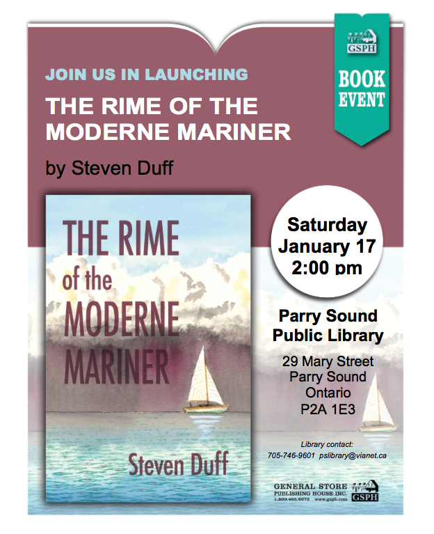
The Rime of the Moderne Mariner
A new book by author and Parry Sound Power and Sail member Steven Duff will be launched Saturday January 17th at the Parry Sound Public Library. The time is 1400 hours (2:00 PM). It should be a good read. I’ll see you at the launch.
 JB – Communications Officer
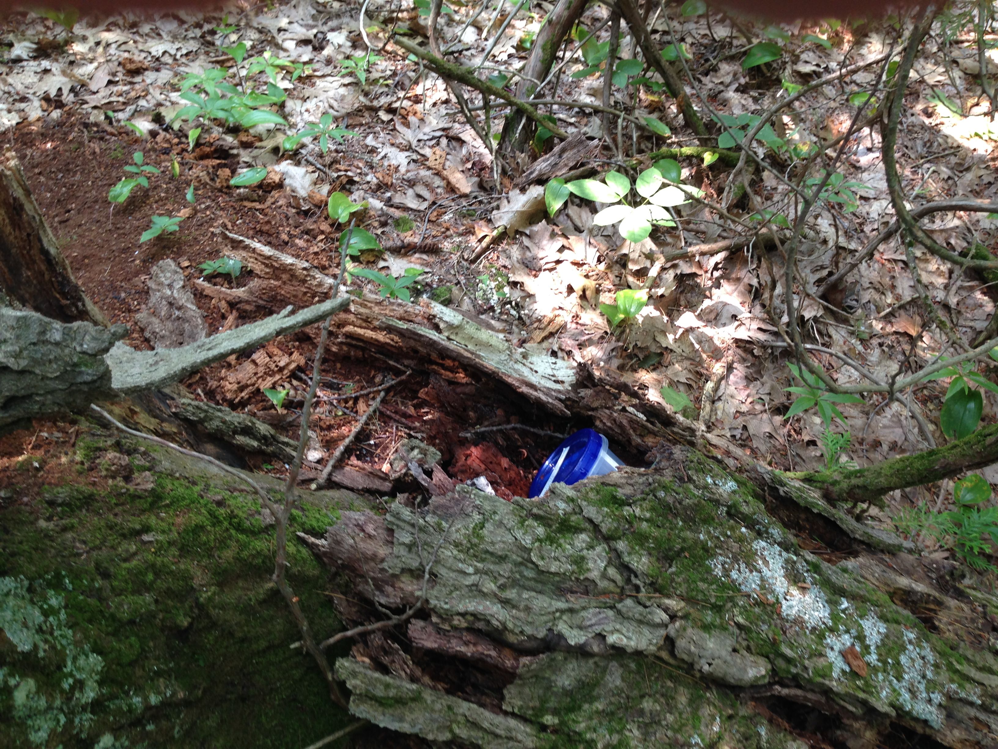
Geocache Placed – Winnett Island
Parry Sound Power and Sail Squadron’s seventh GeoBayCache has been placed and confirmed on Winnett Island. It’s officially Cache #5.
The cache coordinates are:
45.178171º
-80.098477º
This is the same as:
45°10.6903′
-080°05.9086′
Depending on whether you are using a Degrees or Degrees/Minutes format.
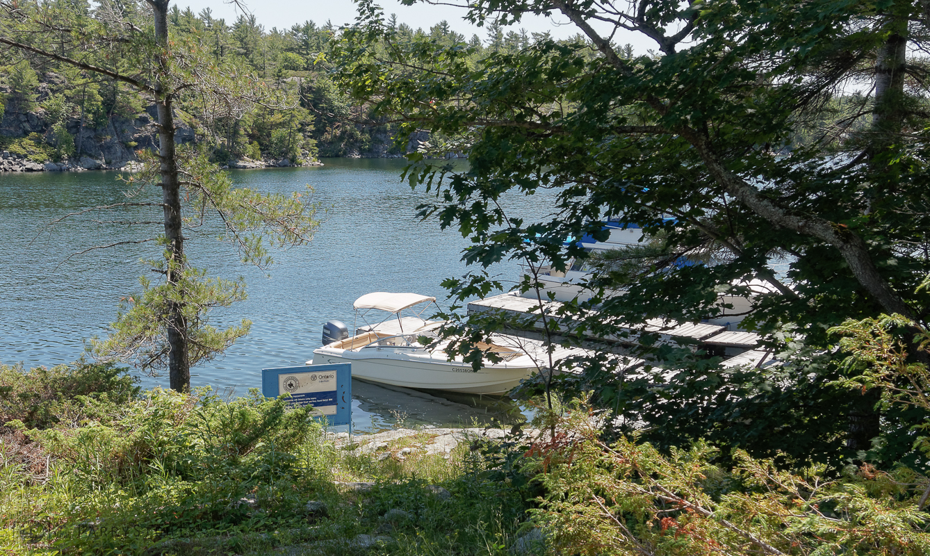
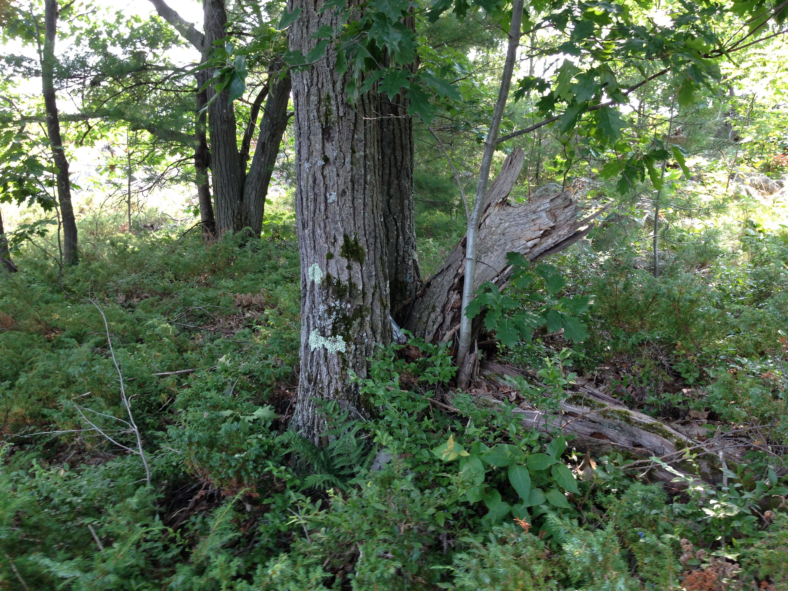
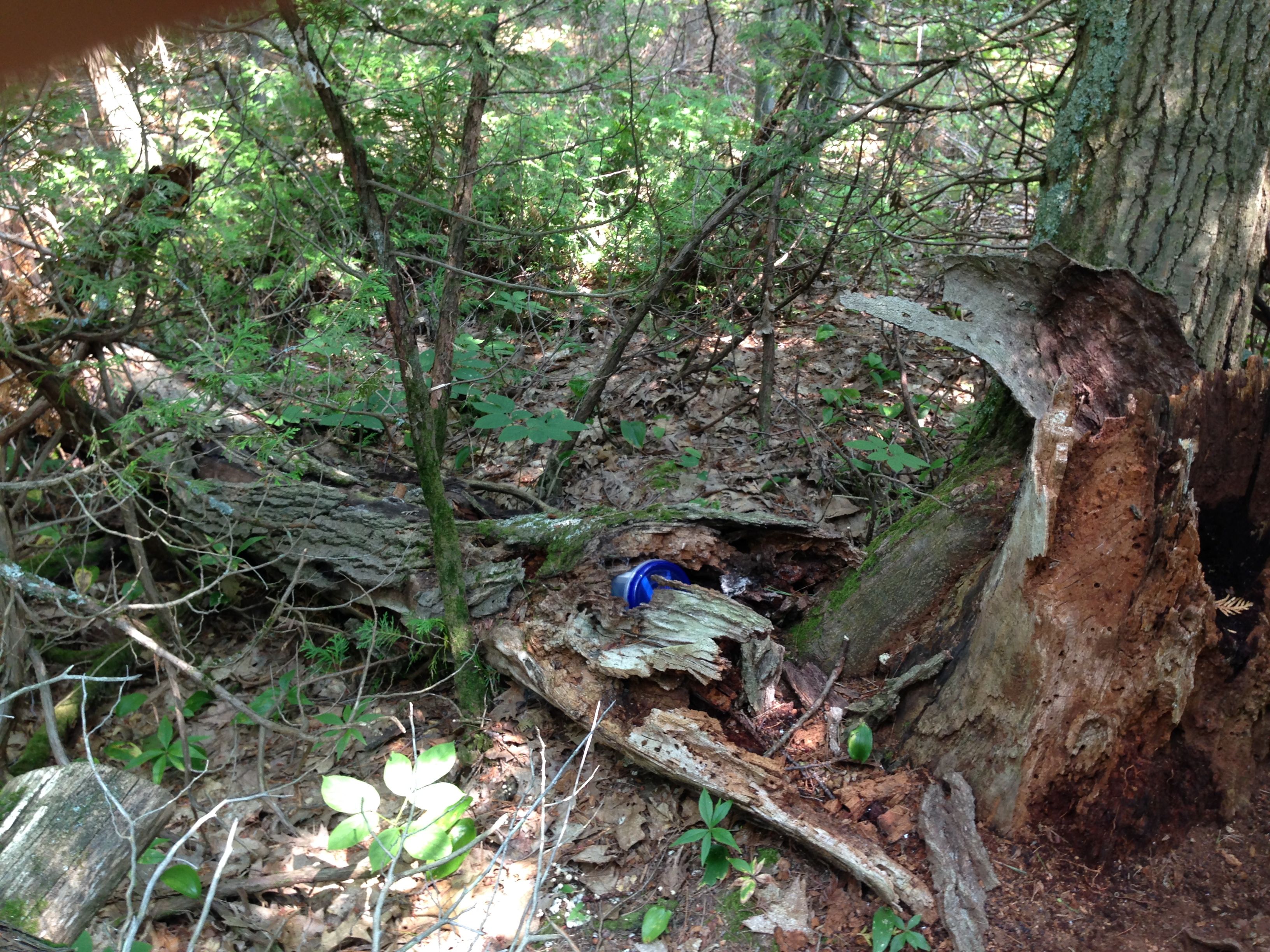
This is an easier cache to access from the government docks at Winnett Island, there seems to be lots of deep water. The cache itself is less than a couple hundred meters away from the dock area. As you are well aware GPS coordinates are at best ‘close’, for a variety of reasons they may be +/- up to ten meters ‘off’. So be sure to look around for the cache in the general area of the coordinates. To make things a little easier a couple of photos are posted below that can help you locate the cache. Please post up a note on our Facebook page, or a comment on this site, when you locate one of the caches. Let us know if the cache is missing (it shouldn’t be too hard to find), or it is damaged or missing any items (notepad, pencil/pen, cache cards).
Cache on Winnett Island

Geocache Placed – Wreck Island
Parry Sound Power and Sail Squadron’s sixth GeoBayCache has been placed and confirmed on Wreck Island in the Massasauga Provincial Park. It’s officially Cache #2.
The cache coordinates are:
45.139549º
-080.107821º
This is the same as:
45º 08.373′
-080º 05.909′
Depending on whether you are using a Degrees or Degrees/Minutes format.
This is an easier cache to access from the government docks at Wreck Island. The cache itself is less than a hundred meters away from the picnic area. As you are well aware GPS coordinates are at best ‘close’, for a variety of reasons they may be +/- up to ten meters ‘off’. So be sure to look around for the cache in the general area of the coordinates. To make things a little easier a couple of photos are posted below that can help you locate the cache. Please post up a note on our Facebook page, or a comment on this site, when you locate one of the caches.
The Cache on Wreck Island
Geocache Placed – Windsor Island
Parry Sound Power and Sail Squadron’s fifth GeoBayCache has been placed and confirmed on Windsor Island, on the southwest of Franklin Island. It’s officially Cache #6.
The cache coordinates are:
45.38033º
-080.34578º
This is the same as:
45º 22.820′
-080º 20.747′
Depending on whether you are using a Degrees or Degrees/Minutes format.
This is a trickier cache to access as there is no government dock. It will mean pulling up to the shore or anchoring out and using a dinghy to get to shore. It has been suggested that the best approach is from the east in an area that is referred to as Windsor Island Harbour. On some charts an anchorage is shown that is close to where the cache can be found.
Geocache Placed – The Pancakes
Parry Sound Power and Sail Squadron’s fourth GeoBayCache has been placed and confirmed on The Pancakes, an island a couple of kilometres south of Snug Harbour. (Our Commander managed to place this one and a couple others last weekend and I’m just getting around to posting them up.) It’s officially Cache #9.
The cache coordinates are:
45.34040º
-080.29472º
This is the same as:
45º 20.424′
-080º 17.683′
Depending on whether you are using a Degrees or Degrees/Minutes format.
There is a government dock on The Pancakes, but it can fill up so be prepared to circle back in an hour if you don’t want to anchor and ‘dinghy’ in to shore. The water is high enough that access to the dock is much easier than in previous years. The island itself is quite flat, ergo the name, and quite easy to get around and explore. It also offers some crude but quite usable bathroom facilities.
As always (You are a Power Squadron graduate aren’t you?) be careful on the water and on the islands. You may come across poison ivy and the protected Eastern Massasauga Rattlesnake. Neither should be a concern if you keep your eyes and ears open and your hands to yourself.
Check out information at the Parry Sound Power and Sail Squadron GeoBayCaching page for information on the Squadron’s geocaching program.
Geocache Placed – Regatta Bay (Franklin Island)
Parry Sound Power and Sail Squadron’s third GeoBayCache has been placed and confirmed in the Regatta Bay area on Franklin Island. It’s officially Cache #3.
The cache coordinates are:
45.38583º
-080.33467º
This is the same as:
45º 23.150′
-080º 20.080′
Depending on whether you are using a Degrees or Degrees/Minutes format.
There is no government dock in Regatta Bay so you will need to anchor or pull up on shore to find the cache. Wet feet are a possibility. Come August you should find Cardinal flowers marking the general area. The cache itself is not really hidden. The idea of the program is to provide boaters with an opportunity to explore new spots in the Georgian Bay Biosphere.
There seems to be lots of water this year, so there shouldn’t be too many surprises if you follow the charted routes. But be careful on the water and on the islands, you are likely to come across poison ivy and the protected Eastern Massasauga Rattlesnake. Neither should be a concern if you keep your eyes and ears open and your hands to yourself.
Check out information at the Parry Sound Power and Sail Squadron GeoBayCaching page for information on the Squadron’s geocaching program.
Geocache Placed – Copegog Island
Parry Sound Power and Sail Squadron’s second GeoBayCache has been placed and confirmed on Copegog Island. It’s officially Cache #8.
The cache coordinates are:
45.25237º
-080.20081º
This is the same as:
45º 15.14220′
-080º 12.04860′
Depending on whether you are using a Degrees/Minutes or Degrees format.
As with the Huckleberry Island Cache there is a government dock, in this case co-sponsored with the Wasauksing Band, so there won’t be wet feet. The cache itself is on the other side of the island from the dock, less than a 100 meters away, and not really hidden. The idea of the program is to provide boaters with an opportunity to explore new spots in the Georgian Bay Biosphere.
There seems to be lots of water this year, so there shouldn’t be too many surprises if you follow the charted routes. But be careful on the water and on the islands, you are likely to come across poison ivy and the protected Eastern Massasauga Rattlesnake. Neither should be a concern if you keep your eyes and ears open and your hands to yourself.
Check out information at the Parry Sound Power and Sail Squadron GeoBayCaching page for information on the Squadron’s geocaching program.
The Dockage at Copegog Island (July 2014)